HydroGeoSenz
Groundwater Intelligence Platform
HydroGeoSenZ is the intelligence layer that connects every drop of data—from sensors in the field to policies in the boardroom. It’s a modular, AI/ML-powered platform built to ingest, validate, analyse, and visualize complex hydrological and geospatial data, transforming it into clear, actionable intelligence for decision-makers. In a world where water data is vast but fragmented, HydroGeoSenZ unifies it into one ecosystem ensuring that every reading, map, and forecast contributes to a living picture of environmental reality.
From Observation to Understanding
- Water systems are dynamic, interdependent, and prone to sudden shifts.
- Governments, utilities, and research bodies need more than static datasets — they need predictive insight.
- HydroGeoSenZ enables this by combining AI/ML, GIS, and real-time telemetry into a single workflow:
- Detect anomalies as they happen.
- Forecast groundwater levels months ahead.
- Map recharge zones, contamination risk, or drought-prone regions with scientific precision.
- Correlate rainfall, lithology, and usage patterns — all within one interface.
A living digital twin of the hydrosphere, continuously learning and adapting.
Platform Architecture
Built for Data Integrity and Scale
HydroGeoSenZ is engineered as a five-layer architecture, each serving a distinct function yet working in perfect sync:
Data Ingestion Layer
- Connects with telemetry stations, IoT sensors, manual datasets, and external databases (CSV, Excel, APIs).
- Recognizes and classifies incoming data as real-time, historical, or survey-based, routing it automatically for processing.
Validation & Cleansing Layer
- Uses machine learning models and domain-based rules to check data accuracy, fill gaps, and flag anomalies.
- Incorporates AI/ML-assisted reconciliation to correct outliers using regression and seasonal baselines.
- Every data point carries a validation status, ensuring complete traceability and trust.
Analytics & ML Layer
- Houses predictive engines including ARIMA, SARIMA, Prophet, LSTM, and Temporal Convolution Networks.
- Supports pattern detection, correlation analysis, and multi-variable forecasting (rainfall ↔ groundwater ↔ extraction).
- Continuously re-trains models as new data arrives, enabling adaptive learning.
Visualization & Decision Layer
- Interactive dashboards, heatmaps, 3D terrain maps, and temporal sliders to view how groundwater evolves over time.
- Map overlays for rainfall, lithology, DEM, aquifers, and administrative units — customizable for any stakeholder.
- “Click-to-compare” analytics — contrast trends between districts, wells, or aquifers at a glance.
Action & Integration Layer
- Supports export to GeoJSON, CSV, and standard government formats for cross-department collaboration.
- This modularity ensures that HydroSenZ can serve as a standalone national platform, or plug into existing hydrology and planning systems without disruption.
Value Proposition
HydroGeoSenZ replaces guesswork with grounded intelligence — empowering users to move from what happened to what’s next.
Unified Platform
One interface for all water datasets, AI/ML models, and maps.
ML-Driven Confidence
Predictive intelligence that enhances data reliability and policy accuracy.
Government-Ready
Compliant with NAQUIM data standards.
Scalable & Secure
Cloud-native/on premise with enterprise-grade authentication and encryption.
Accessible Intelligence
No-code analytics for users at every level — from engineers to secretaries.
ML and Data Science at the Core
HydroGeoSenZ is not just a data dashboard; it is a learning ecosystem.
Its analytics engine employs a combination of deterministic algorithms and adaptive AI models:
Temporal Models
Decision‑ready forecasting of groundwater backed by proven research to support planning and policy.
Anomaly Detection
Applies statistical, ML, and rule-based safeguards to identify seasonality/trend deviations and outliers.
Correlation Analytics
Cross-analyses groundwater variation with rainfall, land use, or pumping data.
Recharge Estimation
Integrate DEM-based slope and flow accumulation with rainfall data to estimate recharge potential zones.
Clustering & Zonation
Use k-means and spatial clustering to identify high-risk or high-potential zones for planning.
Each model’s output is explainable and auditable — crucial for government adoption and policy use.
Use Cases
Applied Intelligence in Action

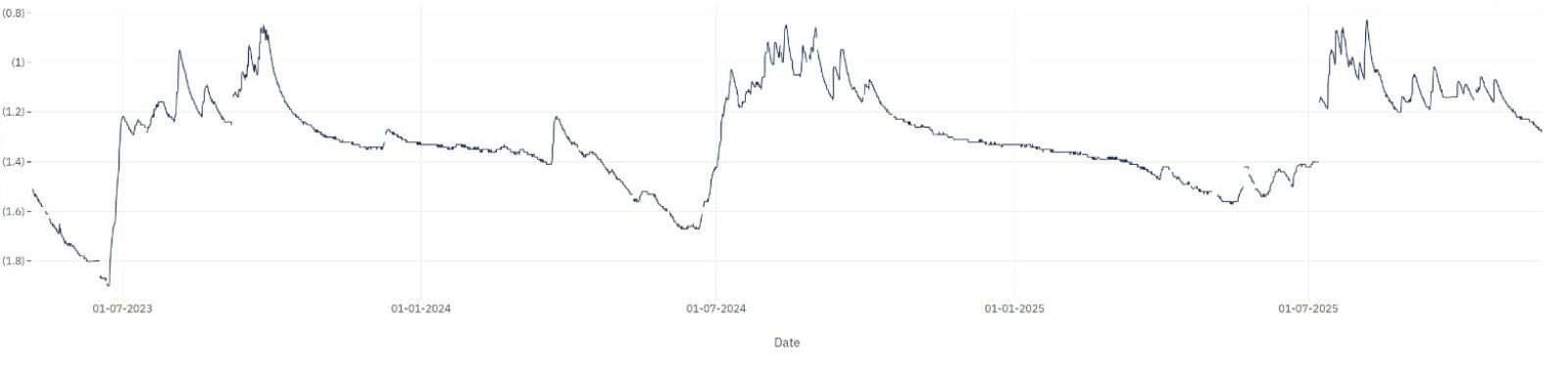
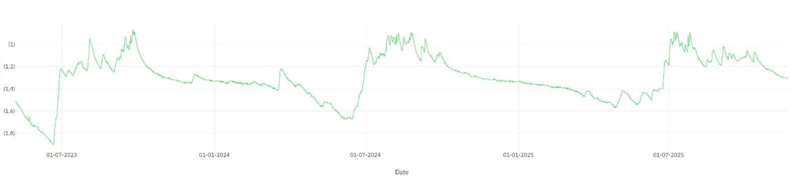
Statewide Groundwater Monitoring
Track and compare real-time data across thousands of wells. Receive alert for declining water levels.

Recharge Zone Identification
Overlay slope, lithology, and rainfall datasets to pinpoint where recharge projects will deliver maximum benefit.

Urban Water Management
Integrate municipal usage data and rainfall patterns to design equitable water distribution and conservation programs.

Policy Planning and Reporting
Auto-generate analytical summaries and policy-ready reports that can be submitted to ministries or funding agencies with one click.

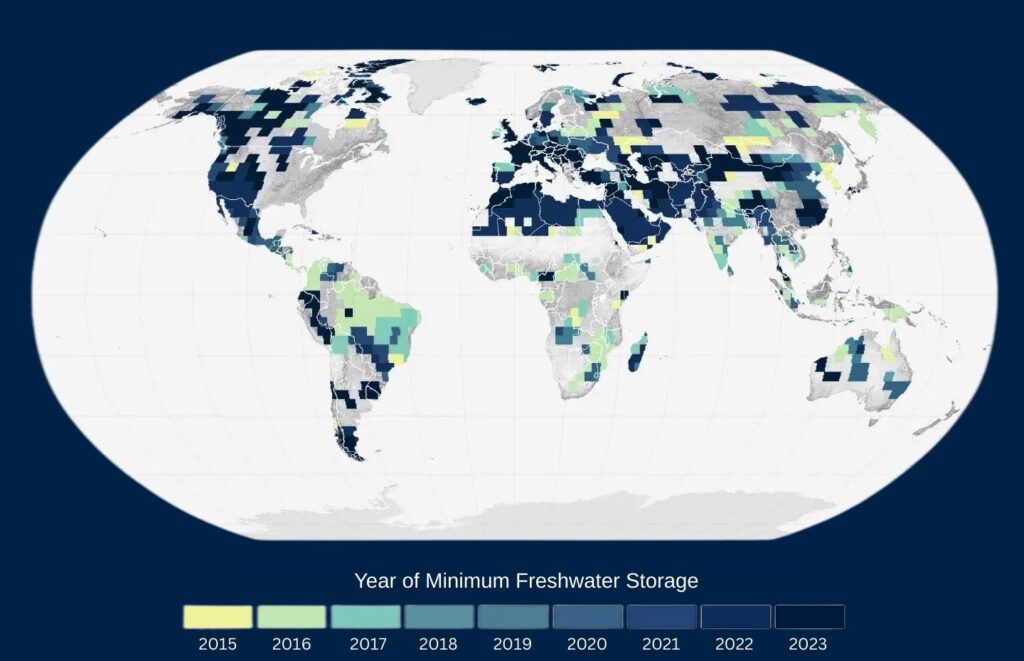
Disaster Preparedness
Model flood and drought scenarios months in advance using predictive AI/ML models.

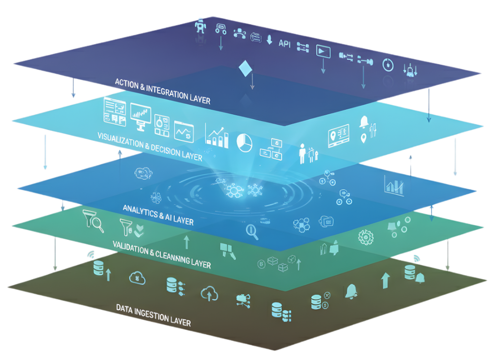
National Groundwater Monitoring & Intelligence
Integrate, validate, and analyse real-time data from distributed monitoring networks across the country.
To explore how it can transform your water programs
HydroGeoSenZ is more than software — it’s an evolving partnership between science, data, and governance.